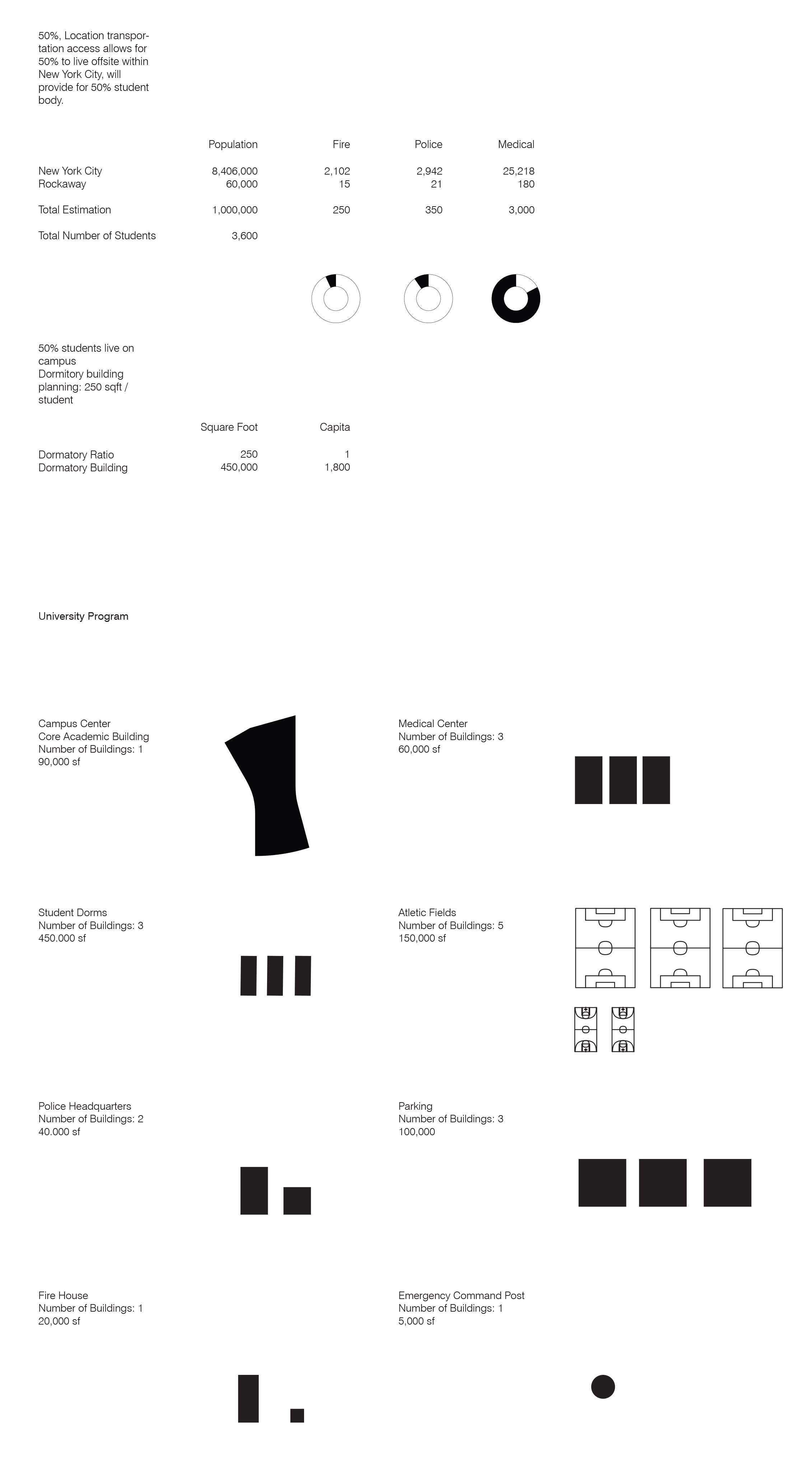
Design Research ● Urban Design ● Climate Resilience
We hope to reconsider urban markers as entry points of network structures, where all systems come together.
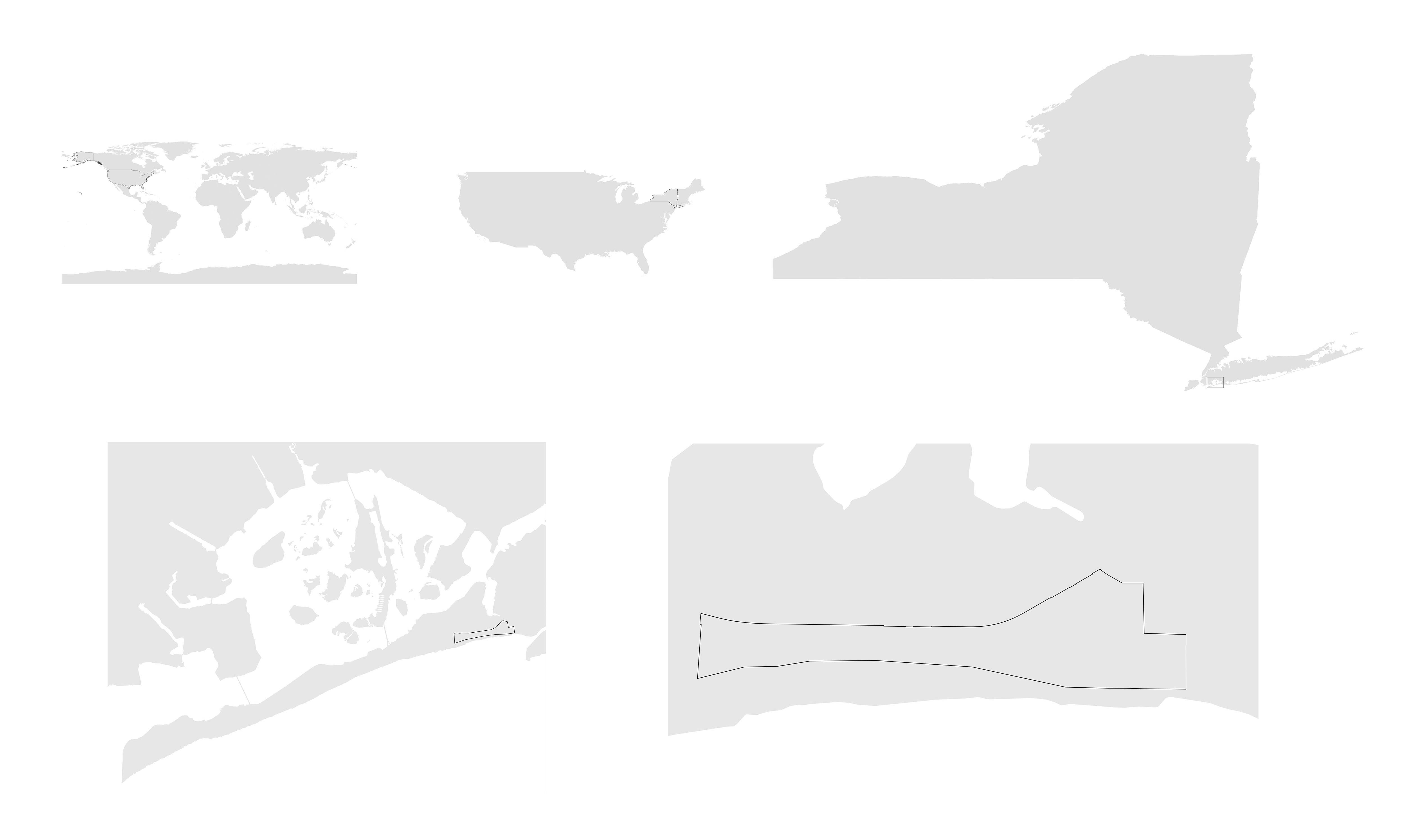
The Alverne East site, located on the Rockaway peninsula in Queens, has an average elevation of 5.5 feet and is surrounded by two water bodies: the Jamaica bay on the northeastern side and the Atlantic Ocean on the southwestern site. Its geographic condition makes it highly fragile and vulnerable to sea level rise and extreme weather events constitute constant threat to our current methods of construction and inhabitation. While the Rockaway community was deeply affected by Superstorm Sandy (power outage, buildings lifted off the ground by heavy winds), it remains a prone area of the New York City area for affordable oceanfront housing and seaside businesses. The recovery was slow but beaches reopened for the 2013 summer season and people flocked back.
While current calculations predict a rise of sea level of up to six feet in the next hundred years, #Tags believes it is crucial that any new building construction designed in the Arvene East site should be adapt to sea level rise and all of what it implies with regards to transportation, energy, drinking water, sanitary sewer and drainage.
After careful evaluation of conditions, #Tags counsels an educational type that learns from recent history and evolves and adapts in synchronicity with the building, neighborhood and available urban networks to address what the area most desperately needs at this specific moment in time. As such, #Tags proposes to rethink traditional police and fire departments in order to makes resources and services available to the local community when emergencies happen. General Assembly’s education fueled co-working model can be a useful precedent in this process.
Rethinking what it means to be a police officer can be a new way to adapt the police and fire station into a center for the local community and create a feedback loop between those who provide public service and those who receive it. Pairing the program of the police academy with that of emergency doctors makes sense on the Rockaway peninsula.
All training would happen within the site area, including ocean training and storm and flood response. This new facility allows for training in its most extreme site, educating first responders about natural disasters where it will greatly impact the built environment. Learning to adapt would is an aspect of the educational program that could be reflected in the building in the way it fortifies against water on the exterior and transforms its indoor.
By being trained in the worst possible conditions, the first responders will be best trained to support the inhabitants of the Rockaways. During a major storm surge of flooding event, the academy would serve as a major refuge site for the neighbors of the peninsula.

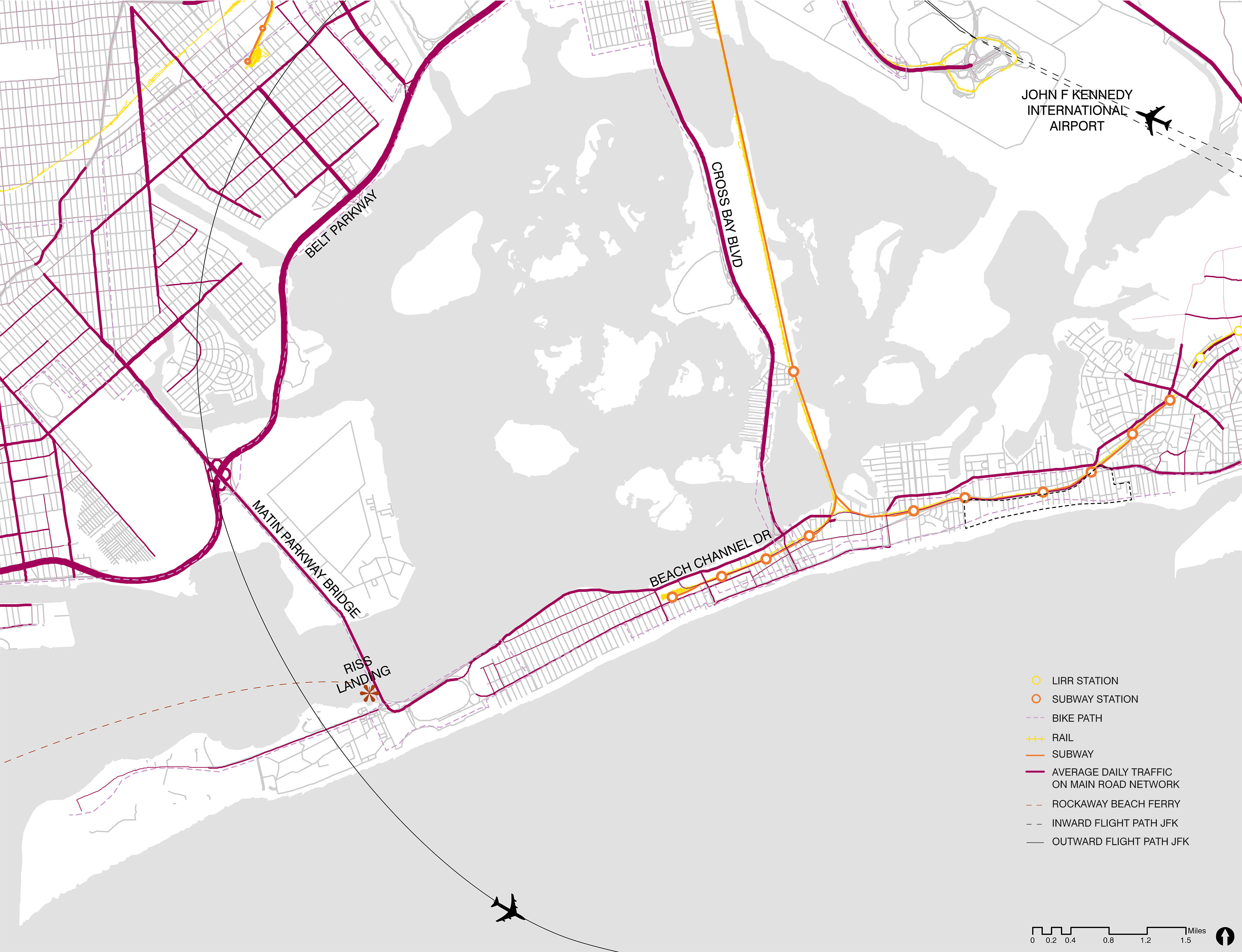
Far Rockaway is primarily a car oriented neighborhood- linearity and sparsity make it unfriendly to foot traffic. Only about half of the peninsular is covered by subway service. The A train runs around 100 blocks from Beach 116 Street to Mott Avenue and connects to Manhattan. However, it does not connect two ends of the peninsular, as the subway splits at Broad Channel station into two branches before entering the peninsular, bringing riders to either the East or West end only. MTA bus service provides supplementary road network coverage.
Far Rockaway connects to Brooklyn via two main roads- Flatbush Avenue from the west end and Cross Bay Boulevard from the east end. There is also the Rockaway Beach Ferry which offers 3 return trips daily during summer months and 1 during the rest of the year, primarily serves to bring people from Manhattan into Far Rockaway instead of out. Our site is also in close proximity to the John F Kennedy International Airport.
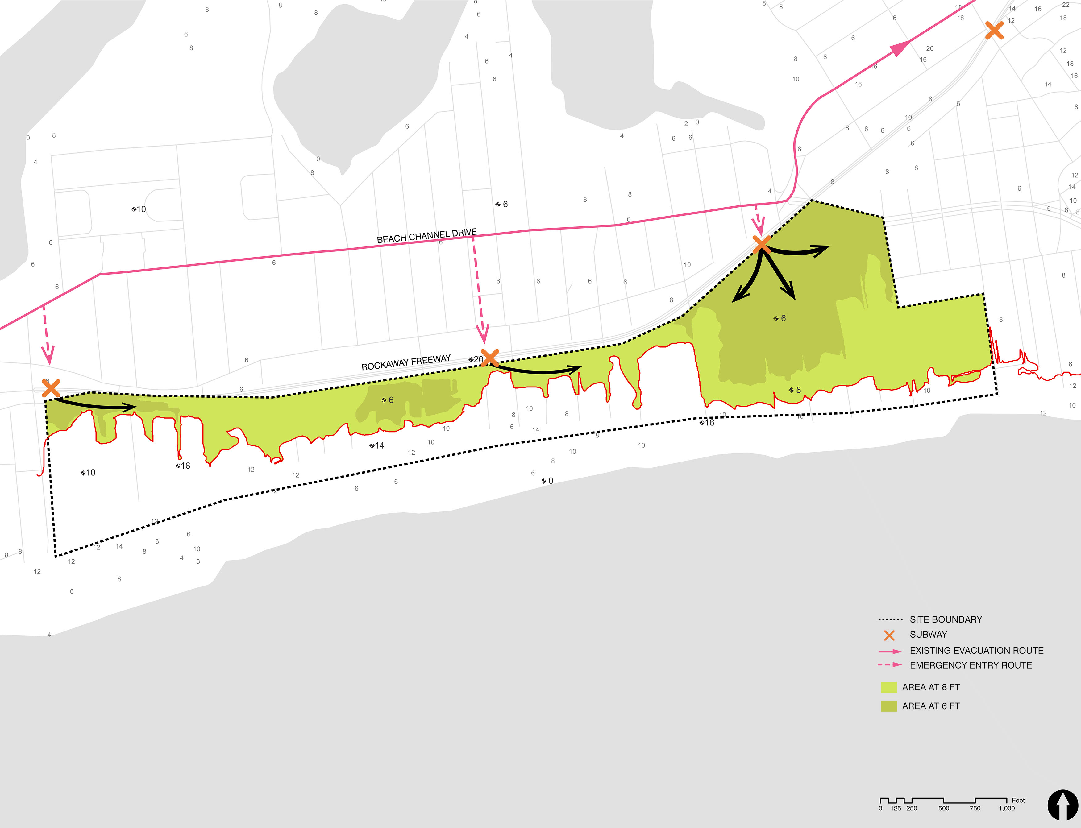
The New York City Hurricane Evacuation Zones highlight areas that may be inundated by storm surge or isolated by storm waters.
The Rockaway Peninsular lies within Zone 1- when a coastal storm is approaching, its residents will be ordered by the City to evacuate first, followed by residents in other zones depending on the severity of the the forecast.
Residents on the eastern end of the Rockaway Peninsular are recommended to evacuate inland on route 878, through Long Island and into Queens to the nearest evacuation center. Evacuees will pass through the First Responders Academy before reaching any safe zones, which makes our site prime location as an evacuation center.

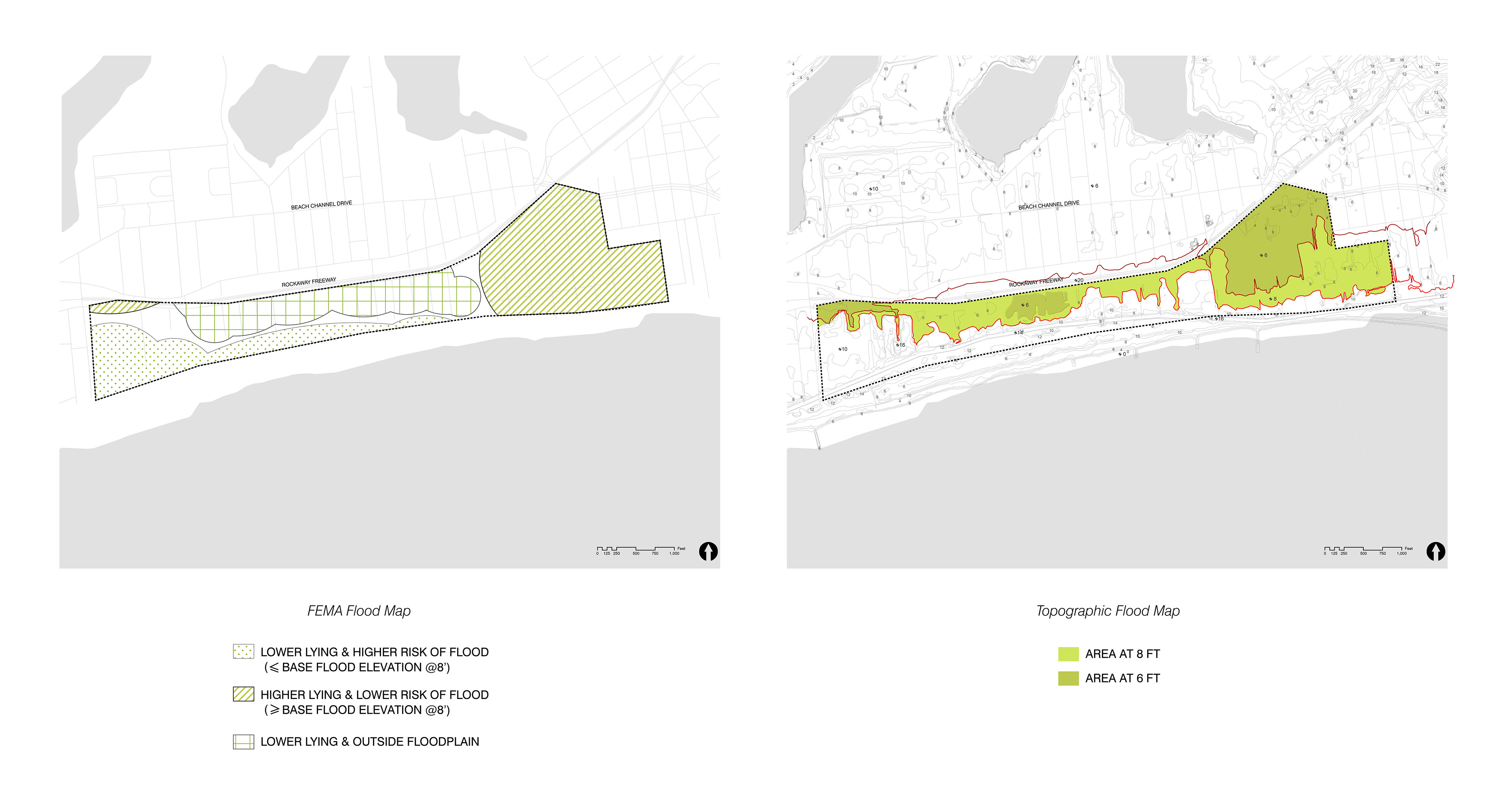
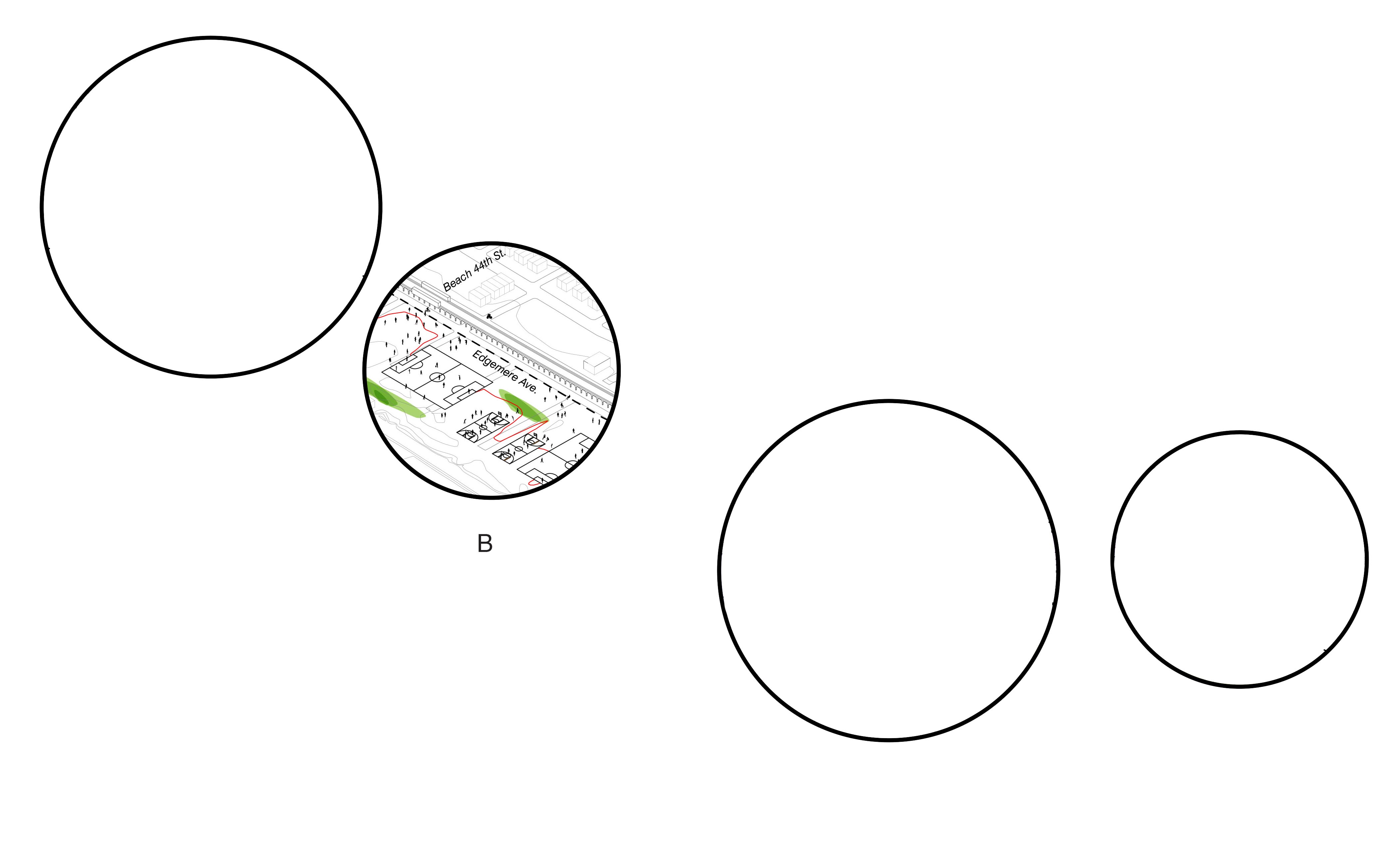
The pink line highlights the present designated evacuation route for people who reside in East Far Rockaway. Taking existing subway stations (Beach 60 Street, Beach 44 Street, and Beach 36 Street) as major entry points into our site, the pink dotted line indicates how evacuees enter our site when passing through the evacuation route. Once within the site boundary, evacueers could travel along the green zone above 8ft base flood elevation to our main building.
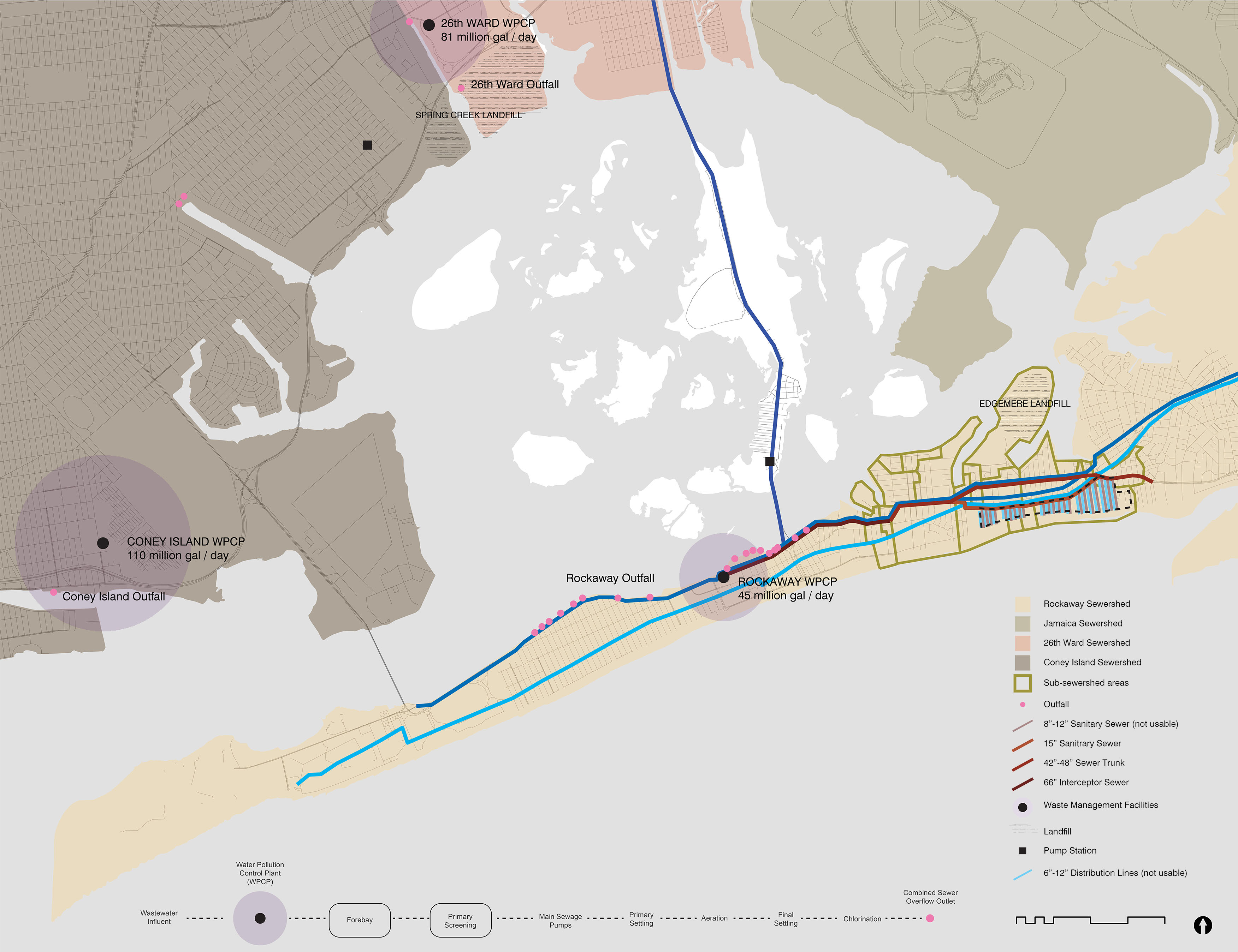
Located in the Rockaway Sewershed, the Arvene site spans a series of fives sub-sewershed area that carry sewage waters to the Rockaway Water Pollution Control Plant (WPCP) located 3 miles West. The Rockaway WPCP treats 45 million gallons per day which are then dropped off onto Jamaica Bay.
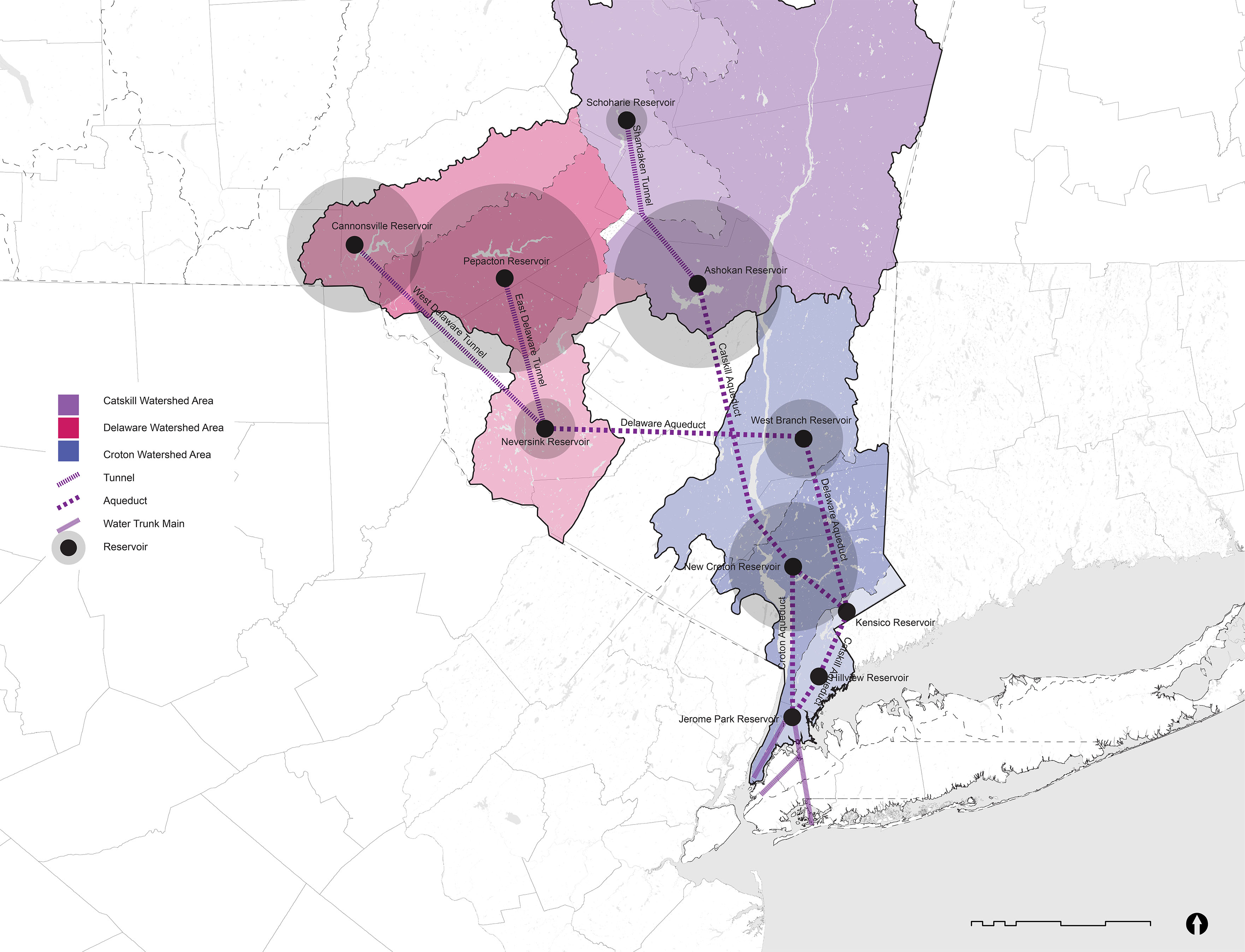
Drinking Water is carried over 150 miles from the mountainous watersheds north of New York City, specifically the Catskill / Delaware Watersheds as well as the Croton Watersheds. Aqueducts, tunnels, trunks and pipelines get reduces as the flow is distributes, spanning a diameter gradient from 40 to 6 feet.
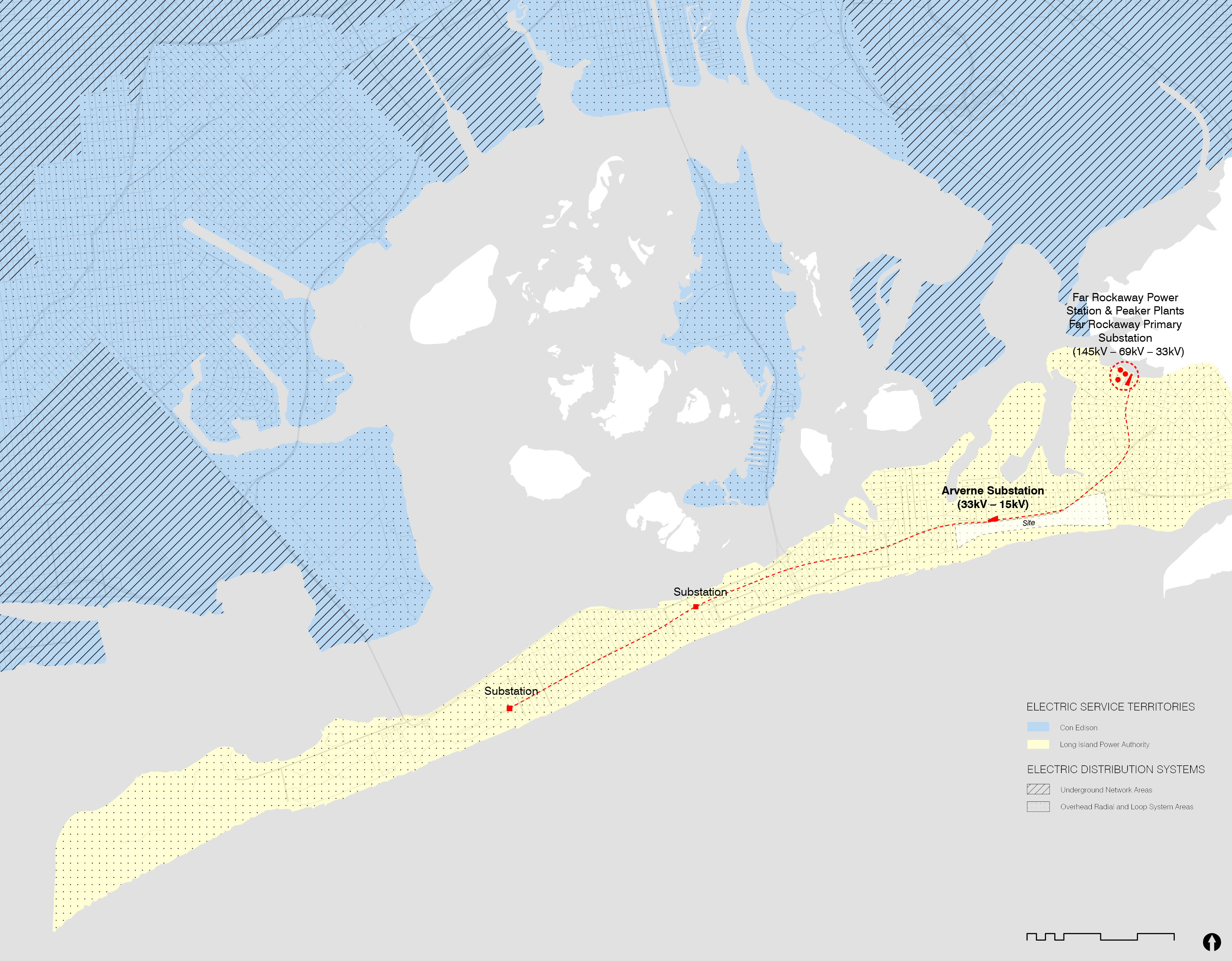
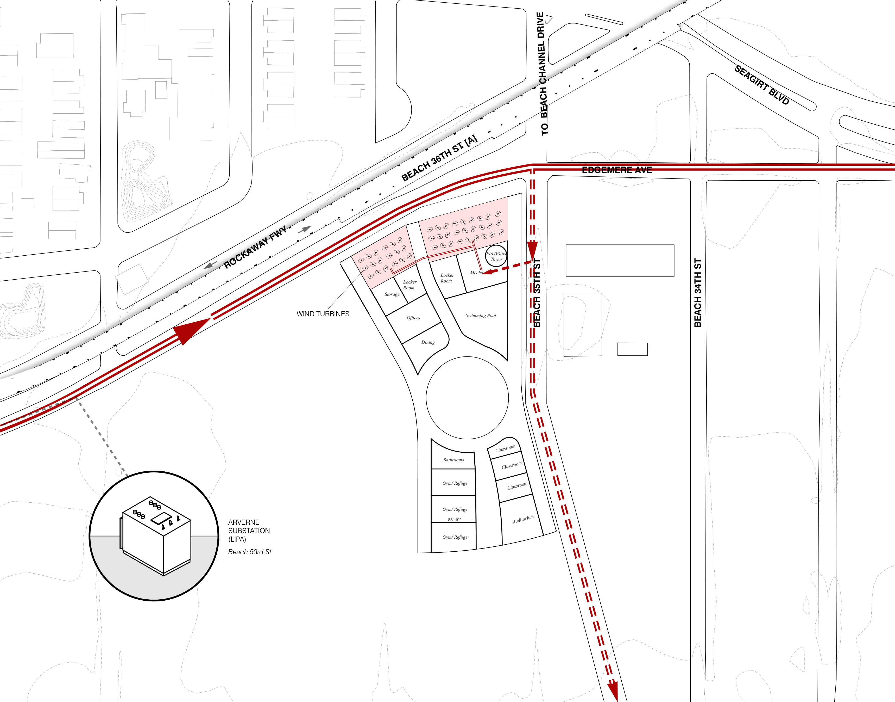
The majority of the five boroughs (Manhattan, Brooklyn, Queens, The Bronx, and Staten Island) rely on Con Edison as their primary electric utility provider. However, the one exception is the Rockaways, which are served by the Long Island Power Authority (LIPA), a public authority controlled by New York State. Power plant distribute power via “transmission substations” that then feed “area substations” to power neighborhoods. Typically, these area substations typically serve one or two neighborhood-level “networks” of customer demand, each of which can serve tens of thousands of customers.
In densely populated areas, such as Manhattan, distribute power via underground network systems, which operate as a grid that can serve customers via multiple paths. However, because the Rockaways relies on LIPA for power, they exclusively use loop and radial systems that uses a simpler architecture and have fewer redundancies. Thus, in cases of electrical power outages, such as storm situations, the Rockaways and other areas that rely on the loop and radial systems are less likely to pull power from another source and more likely to require attention at specific breaks in their distribution feeder lines, which can take longer to restore power.
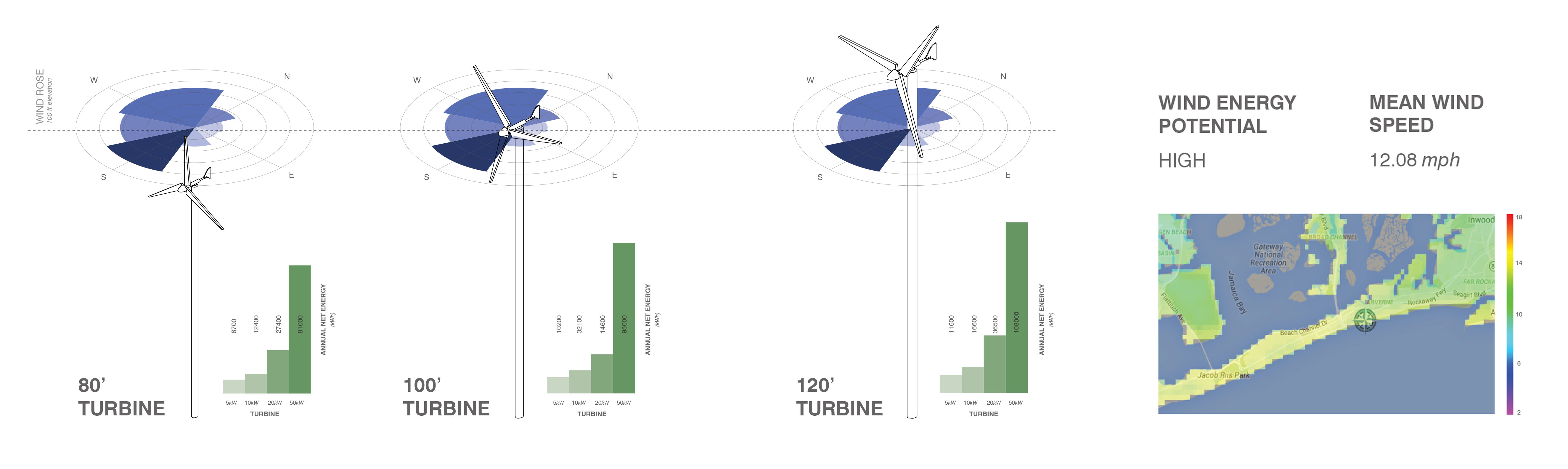
A proposal for a renewable power source on our side that could supplement the Arverne Substation could be wind power. The site, and the majority of the Rockaways, has HIGH wind energy potential due to its above average annual wind speeds. At a 100ft elevation, the site would see an annual average wind speed of 13.22mph and would only increase with higher elevations. The majority of the wind travels from the south and west directions thus wind turbines would benefit the most if they faced a combination of those directions.
Recommendations are based on atmospheric models and historical weather data speeds from NYSERDA.
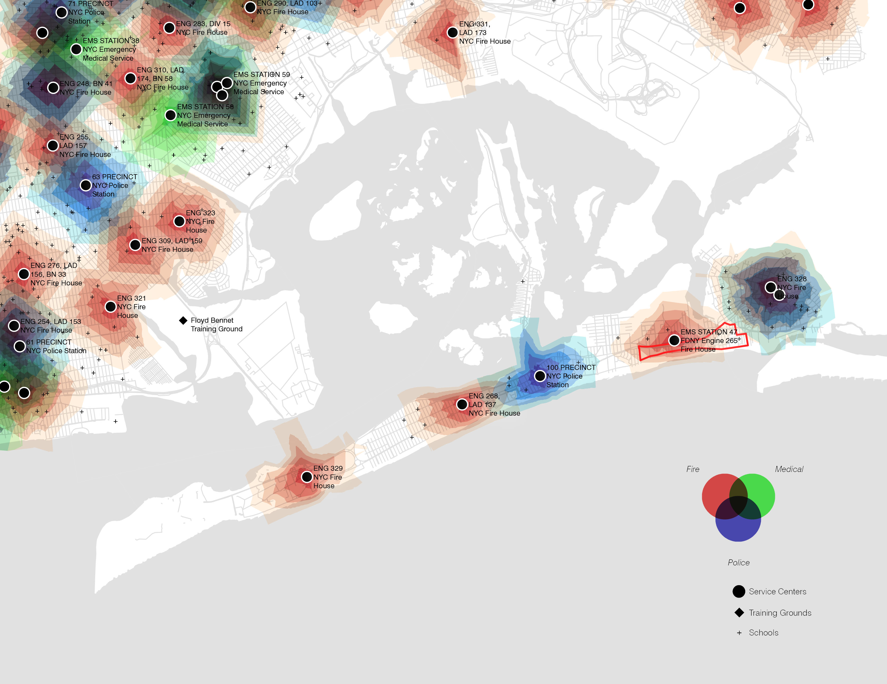
The Service Area for each responder facility reveals a high concentration towards the main geographic bodies of the boroughs. The areas computed show breaks at every minute interval, estimating an approximate travel time to the surrounding neighborhood. The Far Rockaway, while serviced, reveals a greater gap between these three services: fire, police, and medical. Well serviced areas blend colors and show darker tones on the map, merging resources to the neighborhood intended. Regions with no color show a poorly serviced area.
The Far Rockaway, and specifically the neighborhood of East Arverne, include some of these gaps that would need more overlapping of these three types of responders. The new Academy will become part of this larger network of emergency response, increasing the resiliency of the city by decreasing the potential shock in extreme events.
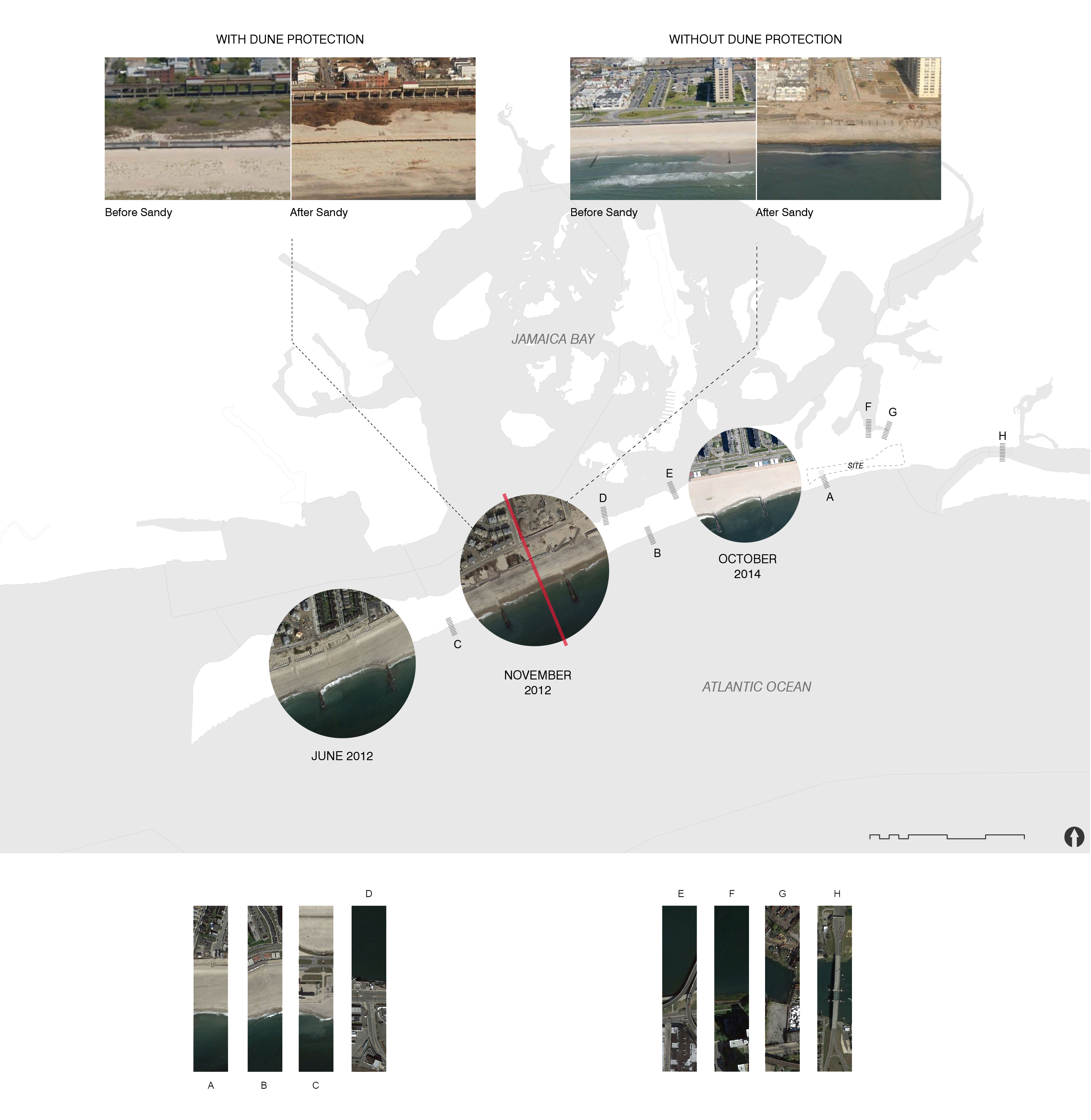
During Hurricane Sandy, The Rockaways peninsula experienced flooding from both Jamaica Bay as well as the Atlantic Ocean. However, due to both the built environment an existing natural conditions, the Rockaways did not experience uniform flooding. One of the most effective conditions for flood protection during Hurricane Sandy were the dunes that existed between the water and the neighbourhoods. The dunes both acted as a physical barrier against waves as well as filtered out much of the sand that would have been pushed into the city.
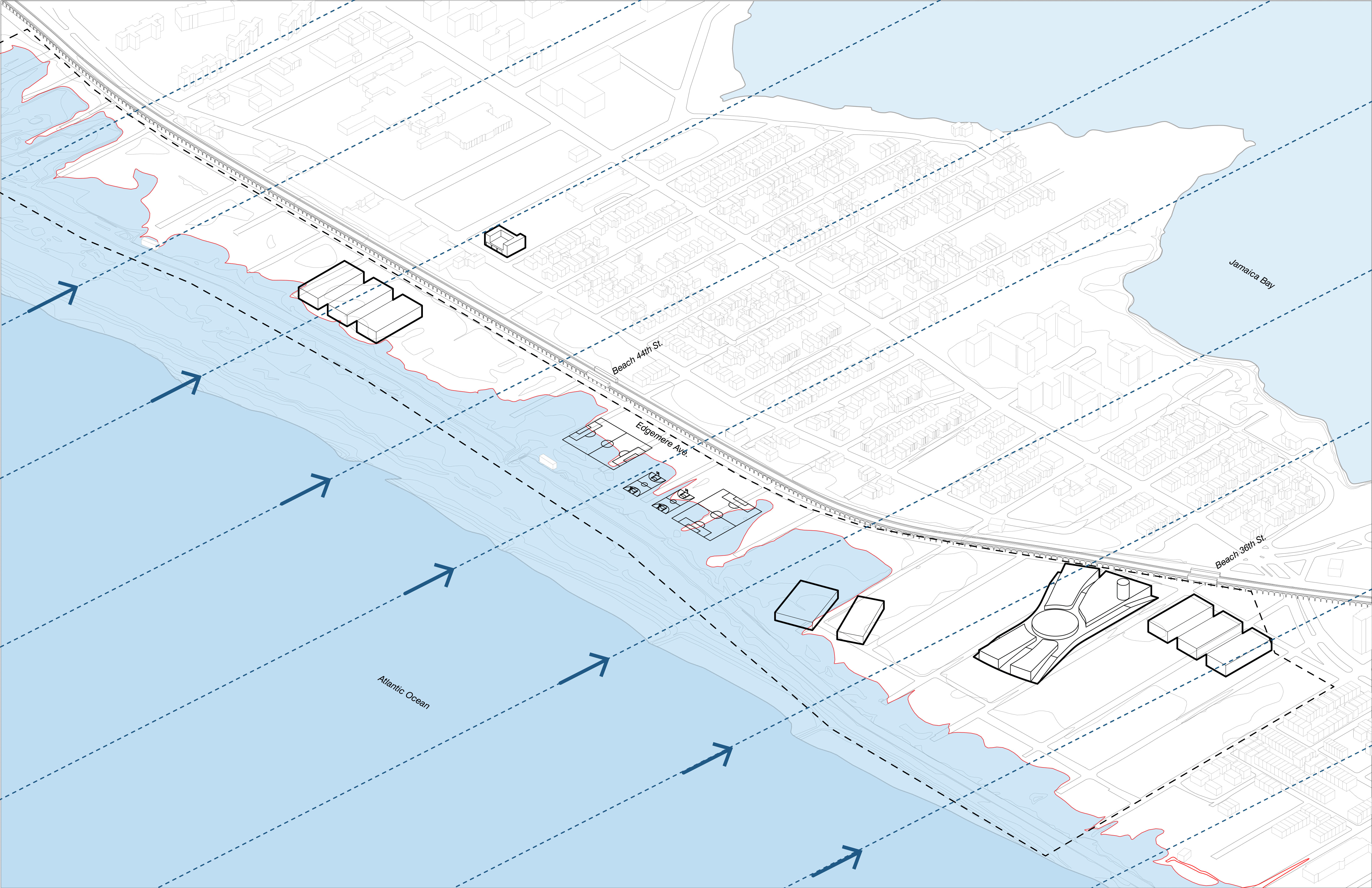
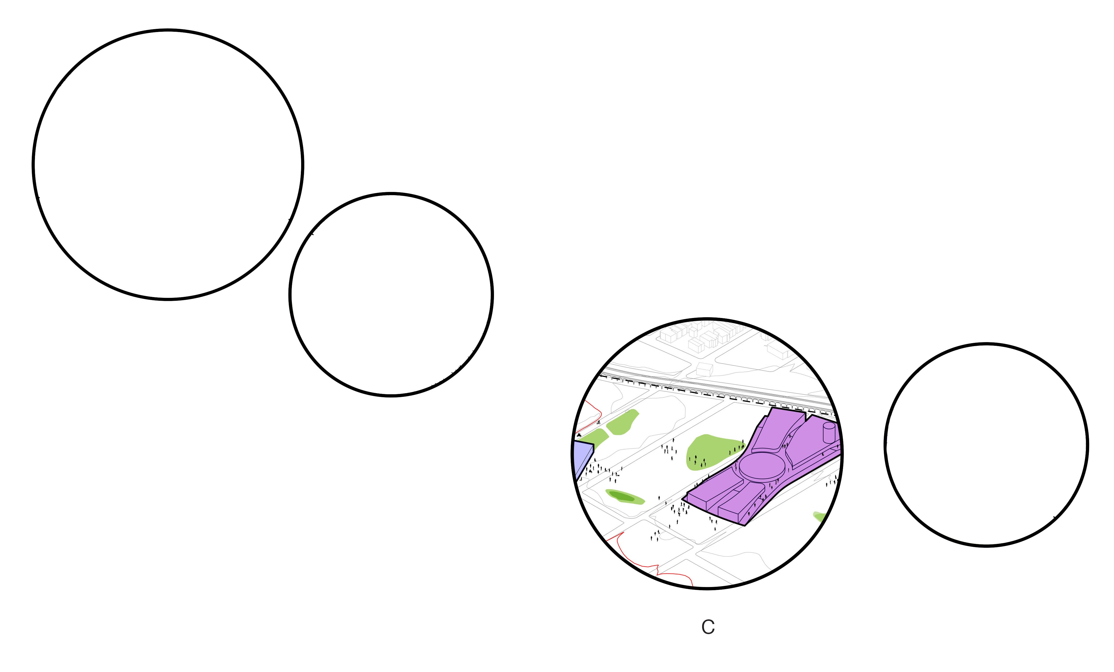
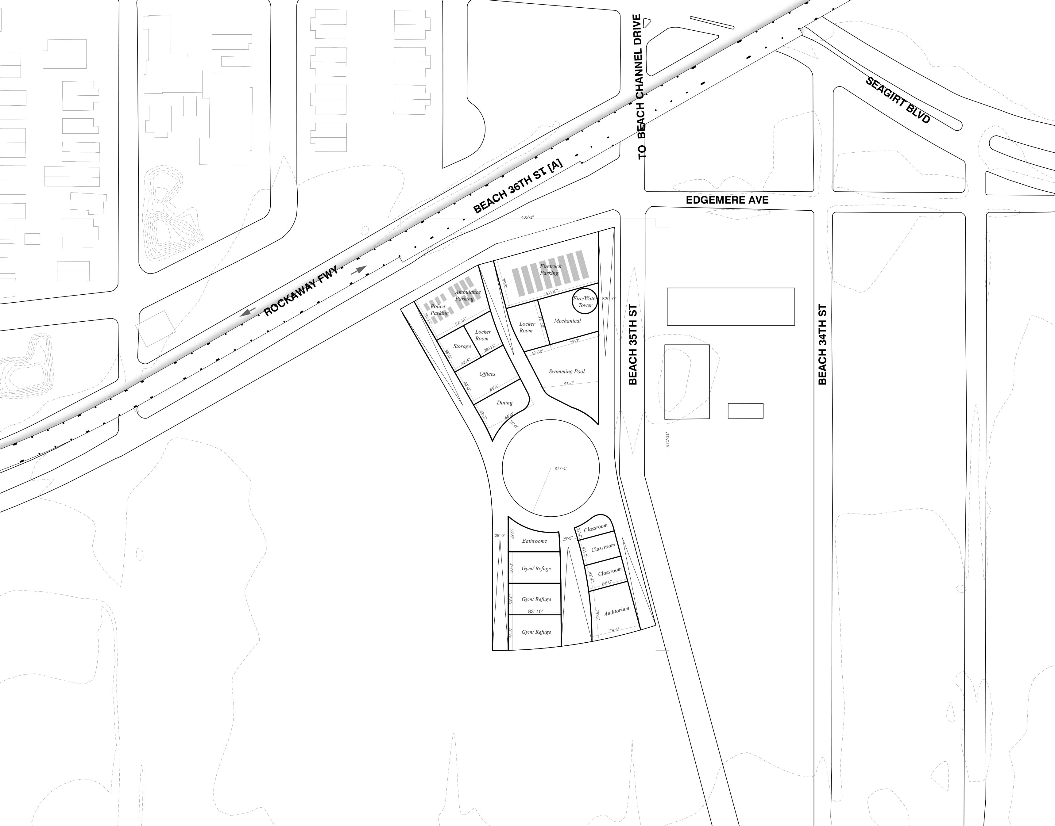
The Proposal at the site creates clusters of programmatic regions while combining the separate First Responders Units into one campus center. The campus is aligned to become an extension of the neighborhood, welcoming the public during normal times of the year and in disaster events. The public engagement allows for parts of the campus to be utilized not only as a training facility for the First Responders but also as a public centerpiece in the Rockaway.
A second campus center integrates Police, Fire, and Medical facilities and headquarters, including parking for emergency vehicles. The nearby fire station, EMS 47, is included in the proposal as an extension of the network of collaboration between these emergency service providers.

Athletic fields serve as both training centers during normal times of the year and as a flood retention strategy during other times of the year. The fields are located in the site that is most susceptible to flooding, and act as buffers to mitigate flooding to the surrounding neighborhood.
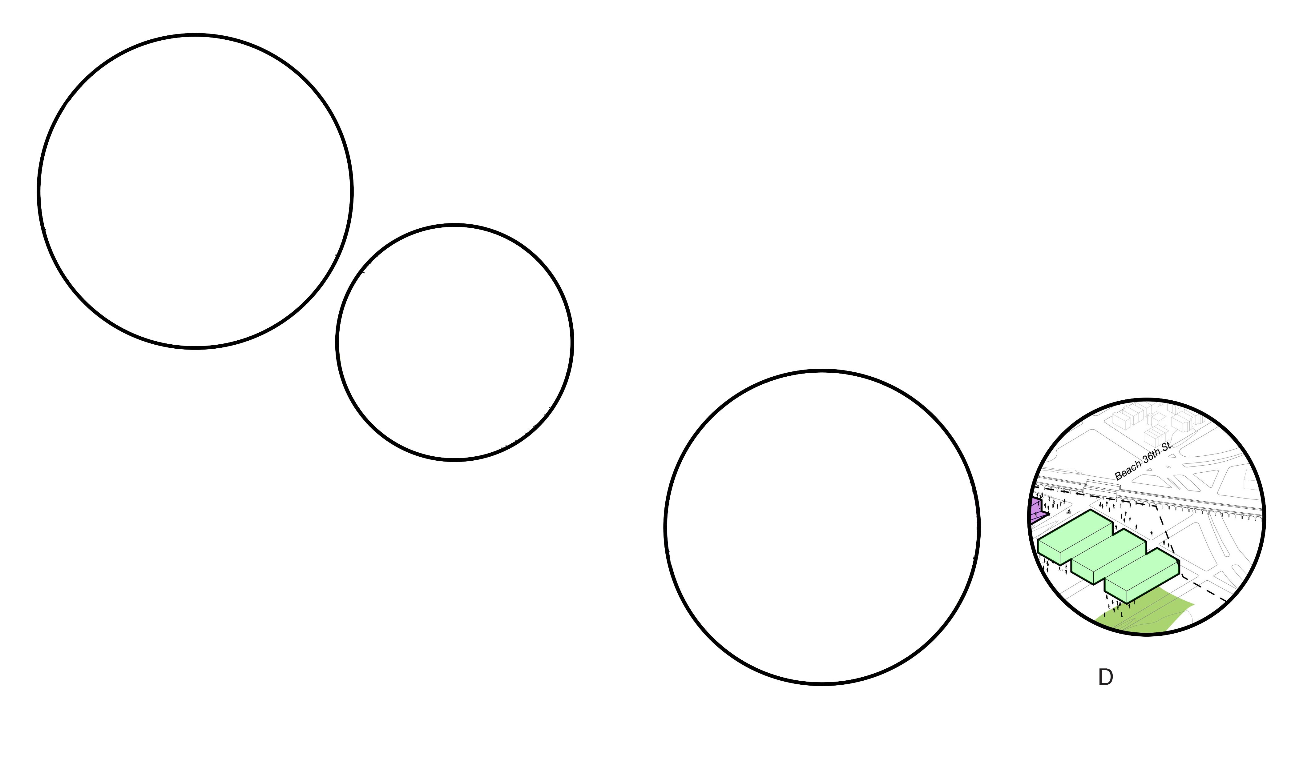
The Main hub of the campus integrates several program necessities, including academic offices, student centers, and training facilities. It is surrounded by dormitories and open space, connecting the 36th Avenue subway stop.
A Medical facility at the southern end of the site serves those who are not able to move throughout the site, with ample park and open space surrounding. It is in close proximity to the campus center and the 36th St. subway station.
The school takes advantage of the existence of the school in direct adjacency to the site to integrate with its existing urban systems such as drinking water trunk, sewage trunk, energy grid and transportation (next to the subway stop Beach 36th street on the A line and close to Edgemere avenue).
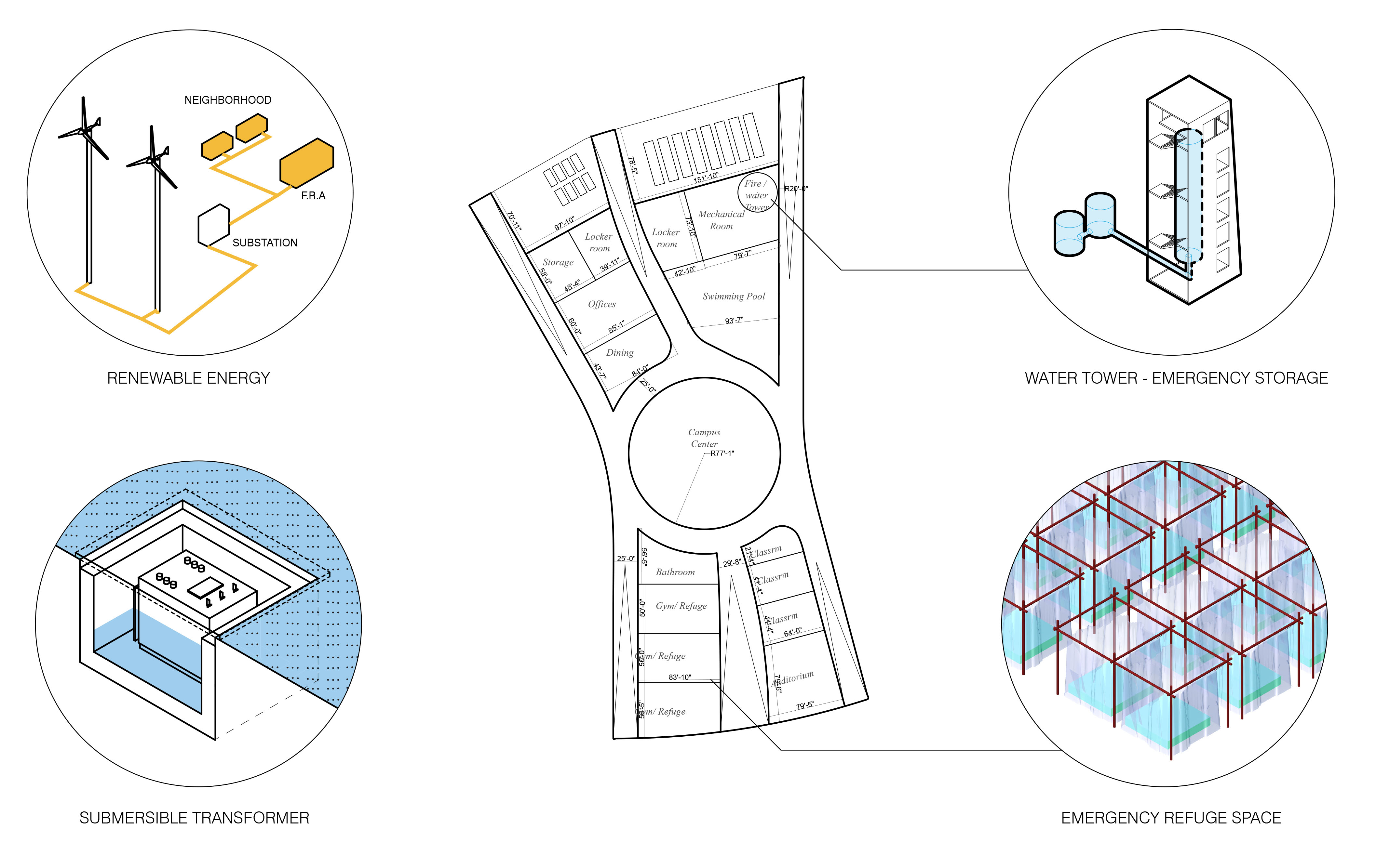
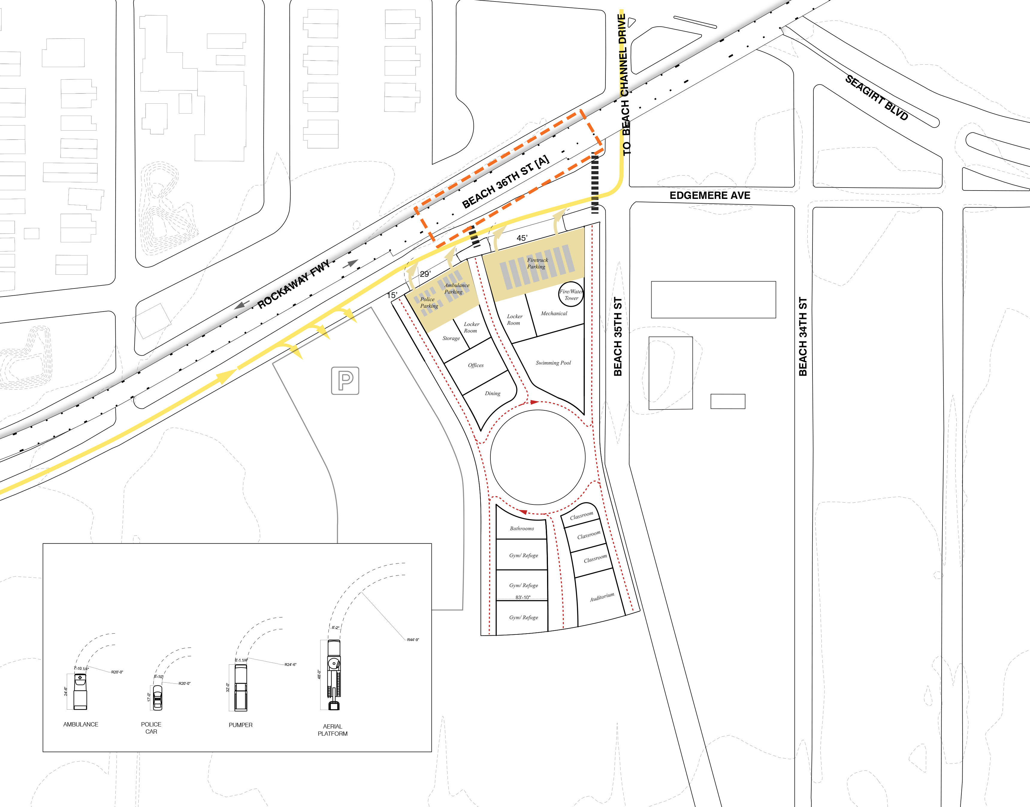
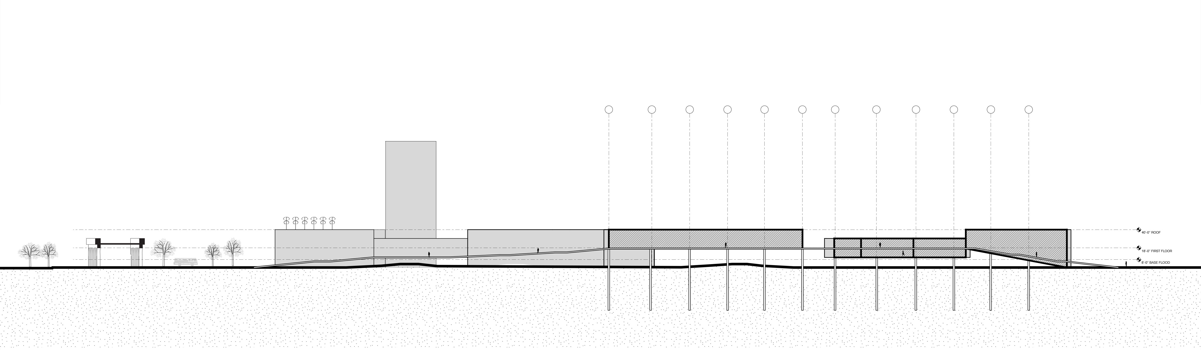
The building is organized in sequence, starting from emergency vehicular parking, to back of house program, to shared semi public amenities (swimming pool and dining hall), to a gathering central space, to community building spaces such as classrooms and auditorium. In case of an emergency, he building could support in its gym transformed in an overnight shelter 1000 people in capacity.
The front face of the Main Building is a series of ramps and street facing car parks for emergency vehicles, both welcoming residents into the facility and introducing them to the first responders. An effective transportation system that connects the building to the neighborhood is paramount especially during the case of an emergency.
Considering how the existing evacuation route directs traffic eastward, car park for evacuees is located on the west so incoming traffic does not disrupt emergency vehicles from exiting the campus. The maximum capacity of parking space is 620 cars, about 60% of the number of evacuees the gymnasiums can hold. Evacuees enter the building via three ramps that bring them above base flood elevation, into the administration office and to designated place of refuge. Car parks for emergency vehicles is sandwiched between ramps. Clear access is designed according to turning radii required for different types of vehicles.
As the site and the Far Rockaways are in a unique position of receiving its electricity from the Long Island Power Authority (LIPA) - making it the only neighborhood in the five boroughs to rely on a separate power source - it leaves it in a potentially vulnerable position. We propose project’s buildings would plug into the existing power grid, which links back to the East Arverne substation at the end of Beach 53rd Street (west of the pictured building on the left).
We would like to also propose a series of helical wind turbines that would top the parking roofs to take advantage of the large exposed surface areas. Ideally, the renewable energy source would supplement daily energy needs of the building. However, in storm situations, we believe that the turbines would be able to generate even more energy (due to storm winds) and would even be able to support the building if it were to be disconnected from LIPA. It would ideally support the building and its inhabitants until power from the grid is restored.
Drinking water flows from the various Reservoirs located upstate New York based on simple pressure. In case of a storm surge yielding a power outage, water would therefore still flow to the First Responders Academy and any building of which water pipes would remain unaffected.
The building integrates with the water systems already in place due to the existence of the school in proximity to the site. During heavy rain and snow storms, combined sewers receive higher than normal flows. In response, a combined sewer with retention tank located under the water tower collects excess water.


For the next steps of the project we hope to investigate a detailed ecological investigation to incorporate the urban systems we established throughout the semester. In order to become the most resilient site and campus possible, we would hope to apply the same logic to an ecological organization of the site. This would be a precise layout of the open areas of the site, increasing areas that can harness excess stormwater from extreme flood events. The ecology of the site would become part of the overall design, integrated into the proposed building and the proposed campus systems.
Additionally, the campus plan would be detailed to incorporate elements of the adjacent Arverne neighborhood, integrating existing schools, facilities, and resources in a larger network within the first responder’s academy. Installing an intelligent framework for the public to engage with the campus, both in emergency and non-emergency events, would ensure safe and swift action at this vulnerable site. Finally, our proposal would become incorporated into the system of facilities within the entire extent of New York City. This new amenity would reshape the administrative and political districts, changing their boundaries to better service the city at large.
We believe that the First Responder’s Academy will become an integral component to the extensive services for the city, creating a stronger physical environment and urban community.


'Le chêne,' pronounced [leuh-sheh-n' means oak tree in French, my native language.